

GOCAD® Mining Suite
3D geological modelling software
Geological understanding for sound decisions
GOCAD® Mining Suite is for integrated multi-disciplinary 3D modelling. It excels in creating geological models where other software applications struggle. Go beyond implicit modelling to create valid interpretation that honours all your data.
Explore the packages available:
It specializes in the subsurface modelling of challenging environments within the realms of exploration, resource assessment, mine sites, and geotechnical modelling.
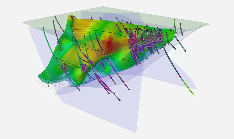
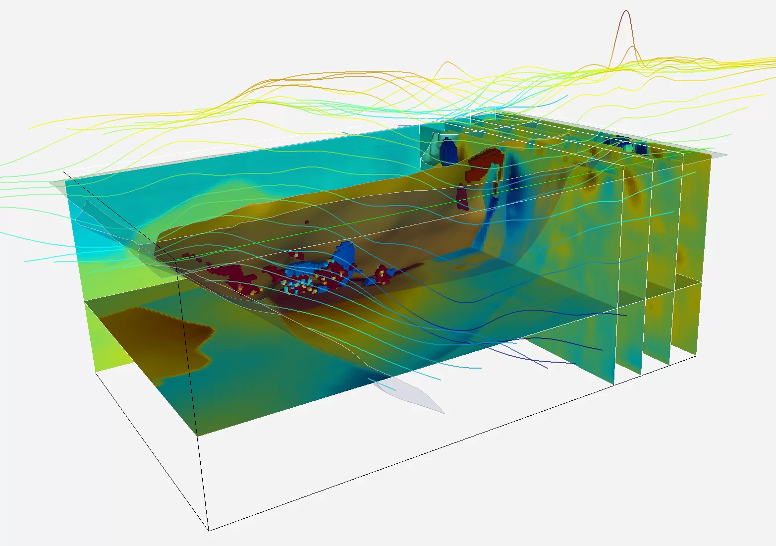
It is the leading 3D geological software for structural modelling, excelling even where drillhole control is minimal or non-existent. It exceeds in geologically-based 3D inversion and geophysical modelling, complex stratigraphic and fault modelling, geotechnical rock mass modelling and hazard assessment.
GOCAD® Mining Suite is a customized extension of SKUA-GOCAD™ (Aspen-SKUA™) developed for the petroleum industry by Aspen Technology Inc (AspenTech).
Related solutions
”“GOCAD Mining Suite is a versatile and continuously evolving platform that supports the advanced interpretation and integrated targeting methodologies needed for the next generation of undercover discoveries.”
Jamin CristallPrincipal Geophysicist – Anglo American
”“This software provides the tools for developing 3D models in a controlled manner while being able to integrate and interrogate all data sets effectively."
Ian E NeilsonConsultant - Structural Geology
Compare our 3D geological modelling packages
Geoscience Exploration Package
Packaged for those seeking a true 3D-GIS environment, building regional, project, or deposit scale 3D models with better management of risk, costs, and timelines.
Package content
This package is designed to build and query integrated exploration models for mineral exploration and geotechnical hazard assessment. From data import to exploration drillhole design, geoscientists from all disciplines can manage their exploration program from one central software application. Its multidisciplinary approach provides reliable results that become an integral part of the decision making process.
Modules included
- GOCAD 3D Mining Viewer + Foundation Modelling Module
- Multi-Core Support for Foundation Modelling Module
- Maps, Cross-Sections, and Well Section Module
- Mining Utilities and 3D-GIS Module
Pricing
The price of a license varies by package. Additional modules may also be included to best fit your individual needs. For more information, contact us.
Import / Export
Some of the main import / export filters are (but not limited to):
- AutoCAD
- DataMine
- ER Mapper Grid (.ers)
- Gemcom
- Geoscience ANALYST
- Geosoft
- ioGAS
- Located BMP
- MapInfo
- Maxwell
- PDF3D
- Surpac
To see all import / export filters available, consult our brochure.
Audience
The Geoscience Exploration Package is best suited for:
- GIS Technicians
- Geologists
Learn more
Advanced Interpretation Package
Focuses on multidisciplinary construction, visualization, querying, and interpretation of integrated 3D data and models.
Package content
This package includes the full capability of the Geoscience Exploration Package plus the ability to digitize and edit 2D cross-sections, multi-parameter interrogation of block models, and geostatistical interpolation, estimation, and simulation.
Modules included
This package includes all the Geoscience Exploration Package modules, plus:
- Well Correlation and Stratigraphic Analysis Module
- Interpretation Modelling Module
- Velocity Modelling and Time-to-Depth Conversion Module
Pricing
The price of a license varies by package. Additional modules may also be included to best fit your individual needs. For more information, contact us.
Import / Export
This package includes the same options as the Geoscience Exploration Package plus:
- Export drillhole logs to CSV.
To see all import / export filters available, consult our brochure.
Audience
The Advanced Interpretation Package is best suited for:
- Geotechnical engineers
- Geologists
Learn more
Geotechnical Modelling Package
Integrates disparate data sources into a single, integrated 3D model for geotechnical modelling and hazard assessment.
Package content
This package includes the full capability of the Advanced Interpretation Package plus specific functionality for complex querying, targeting, and 3D identification of geotechnical hazards.
Modules included
This package includes all the Advanced Interpretation Package modules, plus:
- Geotech Module
- Targeting Workflow Module
Pricing
The price of a license varies by package. Additional modules may also be included to best fit your individual needs. For more information, contact us.
Import / Export
This package includes the same options as the Advanced Interpretation Package.
To see all import / export filters available, consult our brochure.
Audience
The Geotechnical Modelling Package is best suited for:
- Geotechnical engineers
- Geological engineers
Learn more
Integrated Modelling Package
Packaged for integrated modelling work on projects at deposit, project, or regional scale.
Package content
This package includes the full capability of the Advanced Interpretation Package and adds an implicit fault network builder and specific functionality for leveraging multi-disciplinary data with variable, sparse, or discontinuous spatial coverage for integrated 3D mineral exploration targeting. Faulted horizons can be implicitly modelled, updated, or adjusted using a vast array of explicit editing/creation tools in 3D or in 2D cross-sections.
Modules included
This package includes all the Advanced Interpretation Package modules, plus:
- SKUA Structure with Multi-Core Processing Module
- Targeting Workflow Module
- Sparse Module
Pricing
The price of a license varies by package. Additional modules may also be included to best fit your individual needs. For more information, contact us.
Import / Export
This package includes the same options as the Advanced Interpretation Package.
To see all import / export filters available, consult our brochure.
Audience
The Integrated Modelling Package is best suited for:
- Exploration geologists
- Resource geologists
- Structural geologists
- Geochemists
Learn more
Advanced Geophysics Package
This is the only software package available in the market that allows you to create geological models that are fully consistent with any available geological and geophysical data.
Package content
This package includes the full capability of the Advanced Interpretation Package plus specific functionality for geophysical inversion, interpretation, and rapid structural geology incorporation, which is critical to the constrained geophysical inversion process. It includes unique geologically-driven inversion software (VPmg).
Modules included
This package includes all the Advanced Interpretation Package modules, plus:
- SKUA Structure with Multi-Core Processing Module
- VPmg Package Module
- VPem1D Module
- Potential Fields Module
- Electromagnetics Module
- Seismic Module
Pricing
The price of a license varies by package. Additional modules may also be included to best fit your individual needs. For more information, contact us.
Import / Export
This package includes the same options as the Advanced Interpretation Package.
To see all import / export base filters available, consult our brochure.
Audience
The Advanced Geophysics Package is best suited for:
- Geophysicists
- Structural Geologists
Learn more
Stratigraphic Modelling Package
Packaged specifically for modelling of stratified depositional environments and ore bodies with folded and/or faulted 3D grids in a stratigraphic space.
Package content
This is a comprehensive offering that includes the full capability of the Advanced Interpretation Package plus industry-leading stratigraphic and structural implicit modelling. Contains complete geostatistics for resource modelling and estimation for stratified ore bodies, as well as structural restoration capability.
Modules included
This package includes all the Advanced Interpretation Package modules, plus:
- SKUA Structure with Multi-Core Processing Module
- SKUA Stratigraphy and Fault Analysis with Multi-Core Processing Module
- Reservoir Properties Module
Pricing
The price of a license varies by package. Additional modules may also be included to best fit your individual needs. For more information, contact us.
Import / Export
This package includes the same options as the Advanced Interpretation Package.
To see all import / export filters available, consult our brochure.
Audience
The Stratigraphic Modelling Package is best suited for:
- Exploration geologists
- Structural geologists
- Resource geologists
Learn more
Geoscience Exploration Package
Packaged for those seeking a true 3D-GIS environment, building regional, project, or deposit scale 3D models with better management of risk, costs and timelines. This includes compiling and integrating historical data and regular updating of models with new information from disparate multidisciplinary sources, including drilling, outcrop measurement, surface sampling, physical properties, lithology, geochemistry, assays, structural measurements, and geophysics.
This package includes the following modules:
GOCAD 3D Mining Viewer + Foundation Modelling Module
- Provides the basic viewing camera, selection, querying, interrogating, and navigation of a project and data in 3D space.
- Provides visual digitizing and querying of all types of objects in 3D space.
Multi-Core Support for Foundation Modelling Module
- Faster processing for voxets and the use of all computer cores to support heavy voxet operations.
Maps, Cross-Sections, and Well Section Module
- Maps: Fast, professional, and flexible layouts and style templates.
- Cross-sections: Includes grid extraction and deviated well tracks (facies, log, image, etc.), solid filling according to rock classifications and markers, print to scale with annotations, 3D fence sections, drillhole pillars for vertical holes, link to 3D camera, style templates.
- Well-sections, section from well collars, well tracks and overlay, style templates.
Mining Utilities and 3D-GIS Module
- Extensive mining-industry import/export filters.
- Mining-specific applications and functions, e.g. drillhole designer.
- Visualize, interpret, and query geometry and properties on drillhole logs including discrete and continuous properties.
- Spatial and property queries on objects (proximity, trend, inclusion, intersection, etc.)
- Nested and Boolean operations.
- Metadata editor.
- Tabular information display interactive with 3D visualization.
- Download the Mining Utilities and 3D-GIS Module’s brochure.
Advanced Interpretation Package
Focuses on multidisciplinary construction, visualization, querying, and interpretation of integrated 3D data and models. It includes the full capability of the Geoscience Exploration Package plus the ability to digitize and edit 2D cross-sections, multi-parameter interrogation of block models, and geostatistical interpolation, estimation, and simulation. Adding the optional ioGAS-GOCAD Mining Suite Link presents a powerful configuration for querying, interrogating, and visualizing geochemical and alteration signatures in 3D.
This package includes the Geoscience Exploration Package plus the following modules:
Well Correlation and Stratigraphic Analysis Module
- Digitizing/editing on cross-sections, strip logs, and maps synchronized with features; flattening at drillhole markers.
- Automated drillhole correlation using the stratigraphic column.
- Drillhole log ghosting, editing, and zone manipulation.
- Export drillhole logs to CSV.
Interpretation Modelling Module
- Advanced block model visualization.
- Voxet interrogation probe via 3D box, property co-rendering (up to three at a time), real-time slicer, fence cross-section, arbitrary user-defined axis.
- User-defined restricted view of open data (points, lines, surfaces, volumes etc.) in 3D camera window rendered to probe surface; includes 3-property co-rendering.
- Seismic data: full interpretation workflow with auto-picking and tracking in 2D/3D, cross-sections (maps) from probes.
Velocity Modelling and Time-to-Depth Conversion Module
- Kriging estimation engine for geostatistical estimation and simulation on 2D/3D grids and triangulated surfaces.
- Works in concert with variogram analyser e.g. auto-fitting, coordinates transform.
- Deformed grid geostatistics: a better way to unfold data properly.
- Creates velocity models that integrate complex structures
- Performs time to depth conversion.
Geotechnical Modelling Package
Integrates disparate data sources into a single, integrated 3D model for geotechnical modelling and hazard assessment. It includes the full capability of the Advanced Interpretation Package plus specific functionality for complex querying, targeting, and 3D identification of geotechnical hazards.
This package includes the Advanced Interpretation Package plus the following modules:
Geotech Module
- Geotechnical hazard estimation, identification, and monitoring.
- Geohazard dashboard.
- Import and include multi-disciplinary mining data into 3D integrated models.
- Download the Geohazmap Workflow’s brochure.
Targeting Workflow Module
- Geohazard identification using point, curve, region, surface, and grid/voxet data types.
- Combination, inclusion or exclusion, and proximity-based querying.
- Knowledge-driven and data-driven approaches.
- 3D visual reference, reporting, and auditable workflow.
- Download the Targeting Workflow Module’s brochure
Integrated Modelling Package
Packaged for integrated modelling work on projects at deposit, project, or regional scale. It includes the full capability of the Advanced Interpretation Package and adds an implicit fault network builder and specific functionality for leveraging multi-disciplinary data with variable, sparse, or discontinuous spatial coverage for integrated 3D mineral exploration targeting. Faulted horizons can be implicitly modelled, updated, or adjusted using a vast array of explicit editing/creation tools in 3D or in 2D cross-sections. Adding the optional ioGAS-GOCAD Mining Suite Link presents the ideal configuration for querying, interrogating, visualizing, and targeting geochemical and alteration signatures.
This package includes the Advanced Interpretation Package and the following modules:
SKUA Structure with Multi-Core Processing Module
- Implicit modeling of complex fault networks and stratigraphic horizons with or without drillhole data.
- Allows overturned folds as well as reverse and dying faults, etc.
- Works in tandem with a stratigraphic column and includes depositional relationships between formations.
- Leverages multi-core processing capability for rapid processing.
- Download the SKUA Implicit Modelling’s brochure.
Targeting Workflow Module
- Exploration targeting identification using point, curve, region, surface, and grid/voxet data types.
- Combination, inclusion or exclusion, and proximity-based querying.
- Knowledge-driven and data-driven approaches.
- 3D visual reference, reporting, and auditable workflow.
- Download the Targeting Workflow Module’s brochure.
Sparse Module
- Quickly build 3D surfaces from sparse datasets.
- Quickly build 3D geology models from surface data only.
- 3D Structural Fields Interpolator supporting bedding and foliation data.
- Parametric interpolators: NURBS, Bezier, Hybrid.
- Download the Sparse’s brochure.
Advanced Geophysics Package
Primarily for geophysicists, but also has exceptional functionality for structural geologists. It includes the full capability of the Advanced Interpretation Package plus specific functionality for geophysical inversion, interpretation, and rapid structural geology incorporation, which is critical to the constrained geophysical inversion process. Includes unique geologically-driven inversion software (VPmg). This is the only software package available in the market that enables the construction of geological models that are fully consistent with any available geological and geophysical data.
This package includes the Advanced Interpretation Package plus the following modules:
SKUA Structure with Multi-Core Processing Module
- Implicit modelling for stratified geological settings.
- Builds complex fault networks and stratigraphic horizons.
- Allows overturned folds as well as reverse and dying faults.
- Works in tandem with a stratigraphic column and includes depositional relationships between formations.
- Leverages multi-core processing capability for rapid processing.
- Download the SKUA Implicit Modelling’s brochure.
VPmg Package Module
- Constrained inversion code operating directly on the geologic model.
- 3D gravity and gravity gradient inversion and forward modelling.
- 3D magnetic and magnetic gradient inversion and forward modelling.
- 3D self-demagnetization.
VPem1D Module
- Airborne 1D TEM inversion program with the same geometry inversion approach used by VPmg.
Potential Fields Module
- Advanced modelling and inversion for gravity and magnetics.
- Leverages 3D geological models, structure, geometry, and physical properties as inversion constraints.
- Works seamlessly with VPmg and UBC-GIF MAG3D and GRAV3D inversion codes.
- Download the Potential Fields Module’s brochure.
Electromagnetics Module
- Modelling and inversion for electrical and electromagnetic data.
- Electrical: Inversion, forward modelling, and editing of 2D and 3D DC Resistivity and Induced Polarization (IP).
- Electromagnetics: Inversion, forward modelling, and editing of time-domain airborne EM.
- Leverages 3D geological models, structure, geometry, and physical properties as inversion constraints.
- Works seamlessly with VPem1D, VPem3D as well as UBC-GIF DCIP2D, DCIP3D, EM1DTM, EM1DFM inversion codes.
Seismic Module
- 3D forward modelling for hard rock environments (2D and 3D synthetic seismograms).
- Models seismic reflections data using 3D geological and physical properties models.
- 2D forward modelling and inversion provides straight and curved ray time-travel within discretized 2D planes.
Stratigraphic Modelling Package
Packaged specifically for modelling of stratified depositional environments and ore bodies with folded and/or faulted 3D grids in a stratigraphic space. This is a comprehensive offering that includes the full capability of the Advanced Interpretation Package plus industry-leading stratigraphic and structural implicit modelling. It contains complete geostatistics for resource modelling and estimation for stratified ore bodies, as well as structural restoration capability.
This package includes the Advanced Interpretation Package plus the following modules:
SKUA Structure with Multi-Core Processing Module
- Implicit modelling for stratified geological settings.
- Builds complex fault networks and stratigraphic horizons.
- Allows overturned folds as well as reverse and dying faults.
- Works in tandem with a stratigraphic column and includes depositional relationships between formations.
- Leverages multi-core processing capability for rapid processing.
- Download the SKUA Implicit Modelling’s brochure.
SKUA Stratigraphy and Fault Analysis with Multi-Core Processing Module
- Implicit modelling of 3D geological grids for stratified geological settings.
- Builds the optimum grid for geostatistics; faulted and folded grids with parametric space equivalent.
- Leverages fault networks and horizon grid outputs from SKUA Structure.
- Provides the ideal grid for stratified deposit geostatistics and volumetric computation
- Leverages multi-core processing capability for rapid processing.
Reservoir Properties
- 2D and 3D geostatistical estimation and simulation workflows.
- Works with both continuous and discrete properties.
- Advanced search ellipsoid parameters.
- Post-processing functionalities for simulations.
- Wide variety of kriging and simulation methods.
- Proper geostatistical domain blending.

Case study, tips, trainings and how to videos
We want you to thrive using our geological modelling software solutions. Which is why we put at your disposal many resources, case study, tips, training and how to videos;
- Q&A with ERO Copper Corp
- Q&A with the Irish Centre for Research in Applied Geosciences
- Q&A with Mineral Resources Tasmania
- GOCAD Mining Suite – A geological modelling powerhouse – video
- Trainings
- Technical support
- Other resources
Related resources

15 tips in 15 minutes – Geoscience ANALYST Free Viewer
Past event, view here or on our YouTube channel...

Peak finder – Geoscience ANALYST geoapps: Python application
Past event. Link to recording available here.

Geological 3D-GIS query
In GOCAD Mining Suite, you can create points at specific geological contacts for the construction of your geological contact surface...

Attending AME Roundup 2026?
Visit us at booth 416 to see our software solutions in action and discuss your needs with our expert team!

Q&A with Oleg Brovko, Senior Project Geophysicist at Geofocus
Join us in this exciting conversation with Oleg Brovko on harnessing Geoscience ANALYST and open-source technology for advanced geophysical solutions
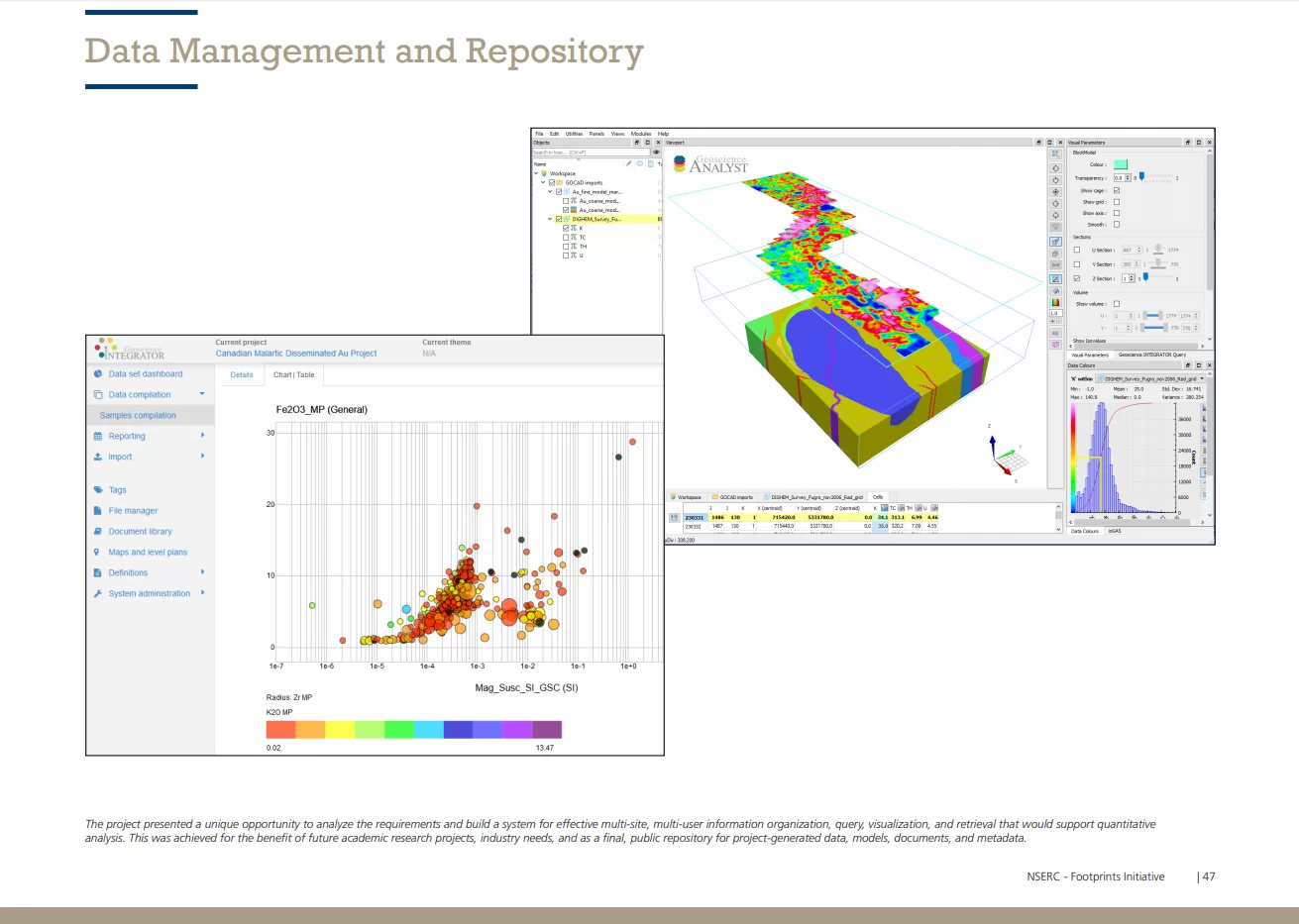
Footprints project public data repository available soon
Project-generated and previously public data, models, and documents from the NSERC-CMIC mineral exploration project, “Integrated Multi-Parameter Footprints of Ore Systems...
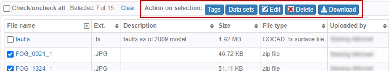
Operations on multiple files
In Geoscience INTEGRATOR, you can carry out various operations on multiple files simultaneously...

Editing file settings
In Geoscience INTEGRATOR version 3.4, users will be able to edit their files’ settings...