Geostatistics and machine learning

We offer solutions and knowledge to properly conduct exploratory data analysis, interpolations, simulations, and enhanced interpretation leveraging the power of machine learning algorithms.

Increasing data volume and complexity calls for powerful interpretation and interpolation tools. We take advantage of advanced geostatistical analysis in harnessing the full potential of GOCAD Mining Suite. Our asset team conducts exploratory data analysis in order to better understand the relationships between geological, geochemical, and geophysical data sets. We offer conventional linear interpolation solutions to generate grids, soil maps, block model properties, etc. We also have the expertise and technology for better managing geological project risk using non-linear interpolation methods, such as conditional simulation and multipoint simulation using training images. These approaches are well known in the oil and gas industry and constitute an excellent way to optimize drilling grids and sampling spacing to decrease exploration cost.
At Mira Geoscience we have expertise in applying machine learning algorithms as custom solutions to complex geological and geotechnical problems. Our team is proficient at identifying the right algorithm to solve a given problem and evaluate its performance in prediction outcomes.

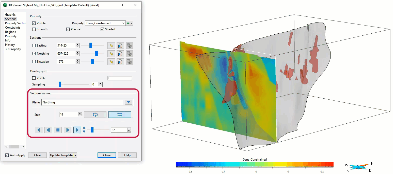
We apply our advanced geological modelling and geophysical inversion capability to create a fully integrated interpretation that captures all the relevant exploration criteria in a single earth model. Exploration criteria are combined using knowledge-driven and data-driven frameworks into a 3D model of relative probability of mineral deposit occurrence that can be used directly for drillhole targeting decisions.
Our team works across the complete spectrum of geophysical techniques. We provide analytical and interpretational value in ore body detectability analysis, survey design, geologically-constrained inversion, 3D geological modelling, integrated interpretation, drillhole targeting, contract geophysical research, and geophysical software development.

Related products

Machine learning is often seen as a black box—hard to interpret and trust. Our experts have developed an in-depth knowledge of the machine learning world and are able to exploit the advantages of both supervised and unsupervised learning.

Related resources

Software releases
January, 15 2019

Geoscience INTEGRATOR AI for exploration

Geoscience INTEGRATOR, the missing AI link for exploration. This unique web-based data management system is designed...
Read more
Case studies
June, 10 2019

Let the data speak!

Four years ago, along with DMT Group, we started working with  JSC Apatit on their Kirovski and Rasvumchorr mines that...
Read more
Case studies
September, 01 2019

Machine learning in mineral exploration

We have applied machine learning as part of custom solutions to complex exploration and geotechnical problems since 2015...
Read more
Case studies
March, 29 2015

Using predictive modelling in mineral exploration

We carried out targeting work for IOCG-style mineralisation in the Mt Dore area of QLD, Australia. We produced a 3D model and predictive exploration map...
Read more
Software tips
November, 04 2019

Visualize structural measurements

In GOCAD you can visualize strike and dip measurements as tablets, discs, or orientation vectors by initializing Structural Graphics...
Read more
Geoscience ANALYST
May, 13 2021

Scripting – Geoscience ANALYST Pro – Virtual Lecture

Past event. Have a look at the video to learn about mathematical and logical scripting in Geoscience ANALYST Pro...
Read more
Geoscience ANALYST
September, 10 2020

How to run gravity inversions in a geologically driven way

Past event, view here or on our YouTube Channel to see how to run a 3D inversion and forward modelling in Geoscience ANALYST Pro using VPmg...
Read more
Software tips
March, 01 2019

Create array property from scalar properties

This command, found in GOCAD's Property menu, creates a multi-dimensional array property from user-selected properties...
Read more
Geoscience ANALYST
July, 07 2022

Inverting time domain data in Geoscience ANALYST version 4.0 – Virtual Lecture

Kristofer inverts TEM data in 1D through Geoscience ANALYST Pro Geophysics to recover conductivity in Geoscience ANALYST 4.0...
Read more
Software tips
May, 02 2022

Searching in the objects tree

Having trouble finding one object out of hundreds in Geoscience ANALYST? Try searching your Objects panel (Ctrl+F)...
Read more
Software tips
August, 19 2019

Cloning import templates

In Geoscience INTEGRATOR, cloning an import template provides a ready-to-edit copy without having to build a new one from scratch...
Read more
Stratigraphic interpretation and modelling
March, 06 2020

Coal industry solutions

Our coal solution provides users the simplicity of 2D grid modelling with the geological complexity of 3D volumetric surface modelling...
Read more

Advanced geostatistics

Mira Geoscience is dedicated to working with clients to reduce exploration risk. Our advanced geostatistical tools enable our team to better assess relationships in data without compromising data dimensionality or subtleties. We offer a wide range of advanced methods in addition to traditional geostatistics and interpolation methods, including simulation of geological models to assess variability in geological domains to better plan exploration drilling and improve resource classification. Simulation of geological data with synthetic drill grids enables us to optimize drill patterns, decreasing the risk and costs of mineral exploration.

Machine learning solutions

Machine learning is often seen as a black box—hard to interpret and trust. Our experts have developed an in-depth knowledge of the machine learning world and are able to exploit the advantages of both supervised and unsupervised learning. Since each problem must be taken individually, we offer customizable algorithm selection and prediction performance evaluation to make sure you get the best results out of your data. We have developed a significant expertise in leveraging the power of artificial intelligence to solve problems in identifying the alteration footprints of mineral systems, classification of borehole geophysical data into consistent lithological categories, and assessing geotechnical hazard.  

Data sets we work with

Mira Geoscience ensures fast, intuitive, and accurate geostatistics and predictive models, regardless of your data types. We work with geological, geophysical, geochemical, and geotechnical data from different mining industry formats. We also have access to numerous predictive algorithms and cloud computing platforms to suit your project’s needs.

Our team of experts

Our specialized geostatistics and machine learning services offer an innovative approach by industry leaders in the geology field. Our geologists, geophysicists and software programmers work together to find the most efficient solution to big data problems. We work in close collaboration with clients to ensure that our geostatistical or predictive models are tailormade to help them bring their project to the next level.  

Our team of experts

Please contact our team for additional information about our products and services